|
Title
|
Burdiehouse Burn Local Nature Reserve
|
|
Address
|
Gilmerton Dykes Street
|
|
Postcode
|
EH17 8LS
|
|
Telephone
|
0131 529 2401
|
|
Email
|
naturalheritageservice@edinburgh.gov.uk
|
|
Facilities
|
Natural Heritage Service, QR Trail, Seating, Interpretation panels, Skateboard and BMX park, Play area
|
|
Background
|
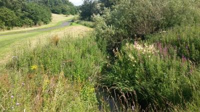
This peaceful green corridor follows the Burdiehouse Burn from Old Burdiehouse Road to Gilmerton Road , running through Southhouse, Gilmerton and the picturesque hamlet of Ellen's Glen. Good tarmac footpaths meander up and down the slopes of this glen. The park has been awarded a Green Flag since 2010 in recognition of it being a quality green space.
|
|
Wildlife
|
This rich habitat includes meadows, young, native woodlands, mature woodland and old limestone quarries; plus the clear water of the Burdiehouse burn. If you pay attention you might be able to surprise a heron fishing in the gently flowing water. You will certainly spot the dipper, with its black and white plumage bobbing from rock to rock in the burn. A kestrel may appear and hover above the meadow in search of rodents and a sparrow hawk could fly swiftly above your head. There is so much to see! Listen for great-spotted Woodpecker, hammering in springtime on the tall trees of this charming redbrick village of Ellen 's Glen. The area includes Moredun wood which was once part of the Moredun Estate, famous for its fertile exotic gardens. Walk amongst these old trees to escape the city, so you are ready to go back to urban life with a satisfied smile on your face.
|
|
Visitor information
|
Main access points can be found at Gilmerton Road, Guardwell Glen, Gilmerton Dykes Street, Lasswade Bank, Southhouse Crescent and Burdiehouse Street.Can be reached by Lothian Bus numbers 31, 37, 7, 3, 8 & 29The Bothy is a community project led by the Friends of Burdiehouse Burn Valley Park and is located on Gilmerton Dykes Street.
|
|
Organise an event
|
Find out how to organise an event
|
|
Green flag
|
Yes
|
|
Management plan
|
Download our management plan
|
|
Location map
|
55.90091853383582,-3.1486129760742187
|
|
Image
|
|